Rabu, 21 Desember 2011

review Osprey Hornet 24

osprey hornet 24 is part of the ultralight segment sack  of osprey. I had test drive this bag when hiking to Mount Pulosari couple weeks ago.
For 2 days trip this bag was still able to accommodate tents, stoves, fuel, food, drinks, sandals, change of clothes etc.
The color of red-black was quite cool. Weighing 560 grams, but then decreases because I dislodged foam on the back. Although the shoulder strap is quite thin but not making the shoulders sore.
the minuses (-)
- The foam on the back reduces the volume of the sack, because it's too thick so I dislodged it. Take them off was easy, because the foam placed in a special bag.
- Design of pockets on the waist strap does not good. The bag is set too far back, so it is quite difficult to open if we are carrying this sack. The solution, I attach an additional small pocket on the waist strap, to keep the camera, and other things.
- Less wide side pockets to accommodate the width of the water containers such as soft platypus bottle. I had to bring ordinary bottled water.
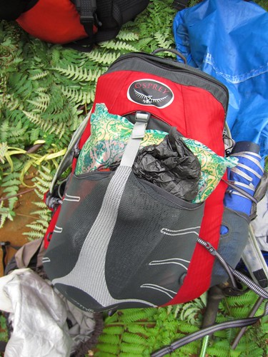
Good things (+)
- Light, especially after the foam was removed.
- There is a special pouch on the back to store the water bladders. Because I didn't use bladder, so I replace pouch function to store the flysheet and tent body.
- Size of 24 liters was still enough to bring equipment and supplies for such a short trip to mountains like Gede, Pangrango, etc.
- Sack material is quite strong and not easily torn
- The color is pretty cool
- There are extra pocket on the front to store items that need to be taken quickly


official link

Pulosari Trip

Saturday 10 des 2011.
At 7 am depart from Kalideres terminal, take bus Murni to Labuan. We will stop at the junction of Mengger (20k/person for bus fare). About 3 hours later the three of us arrived at Mengger, eat at the Padang restaurant next to the shop of Alfamart.
We then chartered a public transportation (black color car) to the starting point for the ascent in the Village of Ciletung. Rents are 60K and the journey took about about 30 minutes. We arrived at the the entrance to the waterfall of Curug Putri. On the left side there is a gate and we paid registration here. Pay entry fee 5k/person.
Continue through the path that has been given pavingblock, then dirt track and the stone. About 1 hour later we saw the waterfall, but just because of drought, the water is almost dry.
Next to the crater of Pulosari. We had to scramble up the right side of the track. Approximately 1.5 hours later we arrived at the crater area. Its location perhaps similar to the same crater in Salak.
We continued hiking but because we never been to Pulosari, we didnt know the right track to the top.
We select a path which through the crater, and then follow a dry river. The longer we hike, the track became more steeper, almost vertical. During that time, I was thinking 'I will never be able to come down using this track again. Its so steep!'.

Slowly crept up the cliffs. At the end of the path, its more difficult because the footing more and more minimal. Luckily, it didnt rain at that time, so it wasnt so slippery. Using roots of trees I finally could climb to the top.
Edge of the cliff is a clump of bamboo trees which were quite dense. Here the weather began worsening and it started raining. We started to climb again, but then lost track due to a dense bamboo forest.

We decided to go down again to find the path, and finally see it on the left side of the
bamboo forest. Apparently we were choosing the wrong track since hiking up the crater! because
there was a circular path that up to the ridges and we didnt have to climb the cliffs. Finally, after starting from the registration post at 11:50, we arrived at the peak of Pulosari at 15:50.
These peaks form a narrow flat land. Before us was an open space, we could see far below to the crater. In the distance appears Mount Karang, Mount Aseupan and villages. Far there appears Sunda Strait which blanketed by the cloud, only the tops of Mount Anak Rakata sticking out from behind the clouds.
Then the rain came again, so we had to cancel our plans to watch the lunar eclipse at that night.

Sunday
Woke up in the morning.
Apparently two of our friends had came at 2 am and made shelter near our tents.
Around 8 o'clock we hiked down. Now follow the circular path which were more secure. Arrived at the crater, we took a rest. 

Now we didnt go down to Ciletung but instead choose another track to Pamengker Village.
The track was slippery and i fell four times. Finally at 10 am we arrived at the village and had a big rest at the house of one villager. 

Kamis, 08 Desember 2011

back to Pangrango

two weeks after I went to Pangrango with my old college friends, I am back to Pangrango, now with my Kaskus friends. The main differences are the weather and the time needed to reach the peak. The weather is clear with no rain, except when I am hiking down and already safe back in Cibodas. Also I hike faster and in 3.30 PM I had already built the tent in Pangrango.
Everything is going smooth here, from Jakarta untill back home. We also have good times.