Selasa, 17 April 2012

Back to Mount Pangrango

Thursday (5/4), we went from Kampung Rambutan bus terminal to Cibodas, the starting point to hike Mount Gede and Mount Pangrango.
Friday (6/4) we started hiking at 8 am. Here we were 15 people from OANC (Outdoor Adventure and Nature Club), a hiking chapter from Kaskus forum. At 1pm we had arrived at Air Panas shelter and we had to wait for others to catch up. After lunch, we continued to Kandang Badak shelter and made camps.
Our original plan was to continue to Pangrango but we decided to camp instead as some from our groups was tired.
Saturday (7/4), Started hiking from 10am and we arrived at the peak of Pangrango at 1pm. The weather was clear. We made camps at Lembah Mandalawangi that night.
Sunday (8/4), After breakfast, we broke camps and hiking down to Cibodas. Started from Mandalawangi at 9am and arrived at Cibodas at 4pm.


Kamis, 29 Maret 2012

Hiking to Mount Manglayang

Saturday, 25 Feb 2012: Our original plan was to climb Mount Burangrang near Bandung. We took a bus from Primajasa pool Cililitan Jakarta to Bandung at 5am. Arrived at Bandung at 7.57am, then had breakfast at Ampera restorant near Leuwi Panjang.
Took an angkot green to Cimahi Pasar Atas. Then changed to yellow angkot at Cimahi to Cisarua SPN then hired this car to take us to Pos Komando Burangrang. Unfortunately after we arrived there, the mountain was closed as it was being used for military exercise.
We changed the plan and now decided to climb Mount Manglayang in Jatinangor. From Pos Komando, we used the same yellow angkot to Cimahi. Then took angkot back to Leuwipanjang. We stopped at Terminal Elang and continued by Damri bus to Jatinangor.
From Jatinangor, we hired ojeks to Baru Beureum. Our starting point was Warung Bu Ipah. About 2.15pm we started hiking Mount Manglayang.
But at first we got the wrong track as we never been here before. We met with a local man who show us the right track fortunately. This track was steep. At some points we had to scramble to get to the top. I was glad that at that moment the weather was clear, because if it was raining i was sure the track will be much slippery and dangerous.
After 2 hours we made it and reached the east peak of Mount Manglayang. We decided to camp here as it was a good location; open to all sides. The weather still clear but it began raining from 6pm to 10 pm.
Sunday 26; after breakfas we broke the tent and continued hiking to the top of Mount Manglayang, about 40 minutes of steep track. Manglayang had some old graves at the top and this peak was surrounded by trees so we couldn't see panorama from here.
We hiked down to Batu Kuda area. Not far from the peak, we saw a big stone which was called Batu Keraton (Castle Rock). Some local people considered this stone as a sacred place and we met four locals who I thought will give 'sesajen' or presents to this stone.
At 1.30pm we arrived at Batu Kuda. Hired angkot to take us to Leuwi Panjang bus terminal and we back to Jakarta.


Senin, 19 Maret 2012

Trip to Mount Ciremai

on 21-22 January with four friends I went to Mount Ciremai in Kuningan, West Java.
Friday (20/1/2012) met with others in Kampung Rambutan bus terminal. We used bus Saluyu to go to Cileunyi at 10 PM, cost 25k rupiahs per person.
Saturday, around 2AM, we arrived at Cileunyi then continue to Cikijing using a small bus (we called it 'Elf'). Around 4AM arrived at Pasar Maja. The weather was cold and it was started raining but not for long.
We walked uphill then found the terminal for car to Apuy village. We hired a pickup car to take us to Apuy then continue to Pos 1. In Apuy we registered first at Ciremai Park office.
Around 8AM we started hiking from Pos 1 Apuy. It was a new shelter. The old track to Pos 2 Arban now covered by bushes. The asphalt road to Arban was abandoned since Ciremai became a national park and almost ruined.
Arban shelter used to be a small wooden hut but now its new and bigger. Continued hiking uphill, we passed shelters like Simpang Lima, Tegal Masawa, Tegal Jamuju, and Sanghyang Rangkah.
Finally we reached Goa Walet around 4PM while the weather became windy and its raining. Made camp here and got rest.
Sunday, at 7 AM we hiked to the peak while its still windy and cold. Took about 1 hour to reach it. We saw the crater and walked around but not for very long as it was quite cold. After took some pictures we walked down to Goa Walet.
Around 10 AM we broke the tents then hiking down. Now we didn't go to Apuy again but to another village, Palutungan, using another trail. The weather is fine but it was raining a bit when we almost reached Palutungan.
It was 5PM when we arrived at the village. Feeling very tired we decided to stay for the night at the house of one villager in Palutungan.
Monday (23/1) at 7 AM we used ojeks to go to Kuningan then got a bus to take us back to Jakarta.

Jumat, 03 Februari 2012

Went to Mount Rakutak

Mount Rakutak (Gunung Rakutak) is a small mountain in Majalaya, not far from Bandung, the capital of West Java province.
This trip was held on weekend, 14/15 Jan 2012. There were four of us from Jakarta, and when we arrived in Bandung, we accompanied by another four hikers from Bandung.
From Bandung, we took public vehicle (angkot) to Ciparay then continued to Cikitu. Here we got off then started hiking through Rumbia Village. Then we entered paddy fields area before starting climb up to Rakutak Peak.
We started from Rumbia around 11 AM and arrived at Peak 1 around 2 PM. From Peak 1 to Peak 2, we had to pass narrow track with deep ravines at right and left of the track. Quite scary.
Then from Peak 2 to Peak 3, there was another narrow track, narrower and longer than the first one! Thanks God at that time the weather was quite good with no wind, otherwise maybe we had to go down.
At 4 PM we decided to make camp not far from Peak 3 or the highest point of Rakutak. From here we could see to faraway villages. Many small hills and mountains surrounded Rakutak, like Mount Cikuray, Mount Kendeng etc.
In the morning we walked to Peak 3. Here we could see the Lake of Ciharus. At first we were planning to go to that lake then continued to Garut, but we had no time.
So we back to camp, broke the tents and hiking down, not to Rumbia again but to another village, which was Ciburial.
We reached that village around 4 PM after had to hike a very muddy track.


Sabtu, 07 Januari 2012

review Terra Nova Laser 35L backpack

I had bought and used Terra Nova Laser 35 backpack for hiking. This backpack is light so I could use it for lightweight hiking. Using a small vertical zipper, we open it and put stuffs inside. So it's quite simple to use.
At first I was little afraid that the zipper couldn't handle the bulging stuffs inside but it turned out that the zipper is OK.
But i was disappointed about the quality of the side part which used to tie the strings. I just used it and it was torn open. So I had to tie the strings to another side part. Also the side pockets were not deep and tall enough to hold 1 litre Platypus bottle.
While hiking, this backpack was quite comfortable to use. So if you search backpack for lightweight hiking, Terra Nova Laser 35L is one of the options.

Selasa, 03 Januari 2012

review Black Diamond Distance trekking poles

I had bought and used Black Diamond Distance trekking pole and here is my review after using it while hiking.
For trekking poles, it has plus and minus. First, the bad ones. Now I couldn't open the lower part of this poles as it has been locked so tight. I am very disappointed with this. And as that lower part made without any rubber grip, it is very difficult to try to hold and pry it open.
I read the manual and try to open it as the manual instructed but with no result. Very frustrating.
But yes this poles is lighter compares to other trekking poles that I have like Leki.
I want to buy another BD Distance poles or something that like it such as Big Agnes Helinox Passport but I am afraid it will get locked tight again. The other choice is to buy pole with ordinary clip-lock style. Hmm I have to think it over again. I will let you know later.

Rabu, 21 Desember 2011

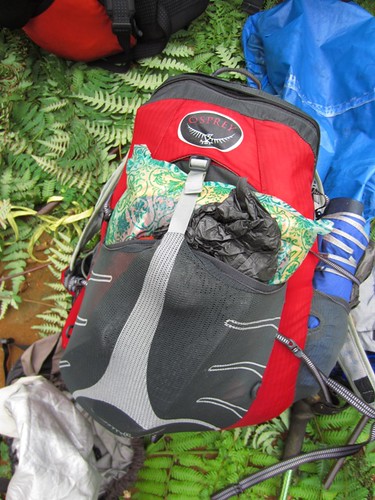
review Osprey Hornet 24

osprey hornet 24 is part of the ultralight segment sack  of osprey. I had test drive this bag when hiking to Mount Pulosari couple weeks ago.
For 2 days trip this bag was still able to accommodate tents, stoves, fuel, food, drinks, sandals, change of clothes etc.
The color of red-black was quite cool. Weighing 560 grams, but then decreases because I dislodged foam on the back. Although the shoulder strap is quite thin but not making the shoulders sore.
the minuses (-)
- The foam on the back reduces the volume of the sack, because it's too thick so I dislodged it. Take them off was easy, because the foam placed in a special bag.
- Design of pockets on the waist strap does not good. The bag is set too far back, so it is quite difficult to open if we are carrying this sack. The solution, I attach an additional small pocket on the waist strap, to keep the camera, and other things.
- Less wide side pockets to accommodate the width of the water containers such as soft platypus bottle. I had to bring ordinary bottled water.
Good things (+)
- Light, especially after the foam was removed.
- There is a special pouch on the back to store the water bladders. Because I didn't use bladder, so I replace pouch function to store the flysheet and tent body.
- Size of 24 liters was still enough to bring equipment and supplies for such a short trip to mountains like Gede, Pangrango, etc.
- Sack material is quite strong and not easily torn
- The color is pretty cool
- There are extra pocket on the front to store items that need to be taken quickly


official link